
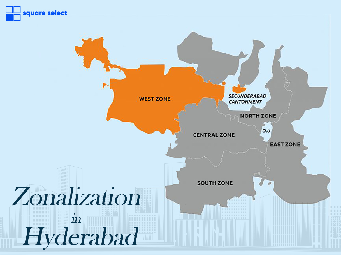
The greater Hyderabad is one of the largest cities in the world and has more than a 1 crore population. Comprising many places, Hyderabad has divided into 5 zones and every zone has many places in it.
The 5 zones represent 5 different parts of Hyderabad that have different purposes to use. With the release of the master plan in 2019 by HMDA, every place has some limitations. Here is the Hyderabad zone areas list
1) Central
2) North
3) West
4) South
5) East
The central zone of Hyderabad – The Central zone of Hyderabad is located in the middle part of Hyderabad which has proximity to Hussain Sagar lake. And also the central part of Hyderabad is considered the oldest part in terms of occupancy as well as legacy. From Golkonda fort to the Charminar, the central part of Hyderabad has its own significance. The central part has 8 places which are
1) Ameerpet
2) Panjagutta
3) Somajiguda
4) Himayat Nagar
5) Kachiguda
6) Khairtabad
7) Karwan
8) Amberpet
According to the master plan by HMDA-
1) The Central part is proposed as Central square and general development purposes.
2) Some parts are proposed as Public utility zones.
South Zone of Hyderabad – The South zone is located in the bottom part of Hyderabad. The south part is widely famous for the statue of equality inaugurated by the prime minister of India. Rajiv Gandhi international airport is one of the largest airports in the world located in the south part of Hyderabad. The south zone contains 6 places which are
1) Shamshabad
2) Adibatla
3) Maheshwaram
4) Shadnagar
5) Rajendranagar
6) Srisailam HighwayAccording to the master plan by HMDA-1) The area near the ORR proposed as a Residential zone2) Area below the Residential zone is proposed as a Conservation zone.3) Small parts are allotted to manufacturing zones.
North Zone of Hyderabad – North Zone of Hyderabad is located in the top part of Hyderabad. Most part is occupied by industries and Army camps. The north zone accounts for prestigious colleges like BITS Pilani, Indian Aeronautical Engineering, and Hyderabad institute of technology and management. The NH44 is the longest highway in India passing by the north zone. The north zone has 7 major places which are
1) Miyapur
2) Pocharam
3) Bachupally
4) Nizampet
5) Bollaram
6) Yepral
7) Shamirpet
According to the master plan by HMDA-
1) The area near ORR can be used for Manufacturing and Residential purposes.
2) Remaining considered as an Open space buffer, a Conservation zone.
East Zone of Hyderabad- The East zone is located in the right part of Hyderabad. Ramoji film city is the center of attraction in the East part of Hyderabad. The majority part of the south zone is covered by the Musi river which is the longest flowing river in Hyderabad. NH65 is passed by the south part of Hyderabad.
1) LB Nagar
2) Nagole
3) Uppal
4) Habsiguda
5) Ghatkesar
6) Nacharam
7) Peerzadiguda
8) Vanastalipuram
According to the master plan by HMDA-
1) Area near ORR is proposed as a multiple-use zone
2) The area which is 1Km radius of the ORR is proposed as Residential use zone
3) The remaining part is the Recreational zone and Conservation zone.
West Zone of Hyderabad- The West Zone is located in the left part of Hyderabad. Osman Sagar and Himayat Sagar are the two largest lakes in the west part. The west zone is under 111GO which is a buffer zone until the incumbent government revoked. Most of the IT companies are located in the west part which makes as IT hub of Telangana.
1) Gachibowli
2) Kondapur
3) Tellapur
4) Kukatpalli
5) Attapur
6) Kokapet
7) Panatncheru
8) Madhapur
9) Appa Junction
According to the master plan by HMDA-
1) The area near Osman Sagar and Himayat Sagar lake is proposed as a Bio conservation zone.
2) Places like Gachibowli, Kondapur, Tellapur, and some other places are proposed as residential zone.
3) The remaining part is considered a conservation zone.